Surveying landscapes with LiDAR Sensors and Terrestrial Laser Scanners
Updated: Sep 1
What is LiDAR measurement?
LiDAR is a method of measurement using lasers, with the time taken for laser pulses to be sent out and returned to the equipment, determining the distance of the object from the sensor. Each pulse forms a “point” in three-dimensional space, forming a “point cloud“ which can be used for a variety of measurement purposes.
At Arboris, we use a drone-mountable LiDAR payload and terrestrial laser scanner, creating point clouds of woodland and peatland.
How to generate point-clouds of UK Tree Species & Peatland

Real Time Kinematic receivers
The image shows the usual setup for an Arboris surveyor, taken near Thurso. On the centre-left you can see the two RTK, or “Real-Time Kinematic” receivers. These connect to the device-in-use and satellites, enabling centimetre accuracy for our surveys. One RTK unit is used for the drone, the other for the terrestrial laser scanner (TLS).
Terrestrial Laser Scanners (TLS)
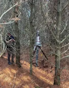
On the left you can see the TLS. The device is large and heavy. This can prove difficult to manoeuvre in dense woodland, especially conifer with low, sprawling branches, like you can see in the image taken near Strathy Point, Northern Scotland.
The data outputs from the TLS are very similar to the drone-mounted LiDAR sensors, although the TLS is more accurate. Consequently TLS data acts as a “ground-truth” for other data sets.
We are currently using this device to generate point-clouds of UK tree species at various ages. These are put through software and scripts to generate 3D models, giving a volume and consequently an estimated carbon content.

Drones
This is the drone that we use to capture most of our data from the air. We attach our LiDAR and RGB payloads to this drone, which is very versatile and can be flown in poor weather conditions, in rain and 30mph+ winds, although this is suboptimal. The target ideally mustn’t move, as it can produce a blurred stitched image and point cloud.
Our 45megapixel RGB payloads take high-resolution images of their targets, which are then stitched together into an orthomosaic. We make sure to fly at particular heights so that a specific resolution can be achieved. For example, a flight for the purpose of examining individual plant species within an area, would want very high resolution and would fly lower.

RGB Drones in action
This image is from a 2022 trip up to Pike Law peatland within Raby Estate. As the site was relatively inaccessible, it required hiking up with a smaller drone. Consequently at this type of site LiDAR data is not easily obtainable, but RGB data is more than collectable.

Peat Bogs
This image is from a peat bog at Strathy Point. Laser scans of haggs and gullies were taken to create point clouds, from which exposed peat and fill volumes could then be calculated.

Tree Plantations
This image shows the TLS within a young sitka spruce plantation in North Yorkshire. Occlusion (blockage via branches, needles, leave etc.) is high in dense plantations such as this, so TLS placement for optimal scanning positions becomes very important to collect quality data. As with the drone, low wind speeds at ground level are important. A moving forest produces a blurry point cloud which cannot be used to form 3D models further along the process.


Comments